
Hurricane FAQ
Frequently Asked Questions
Watch / Warning
What's the difference? When are they issued??
Jump To:
Tropical Storm
Watch/Warning details for...
Hurricane
Storm Surge
Extreme Wind
Flood Advisory
Flood
Flash Flood
Flood Emergency
Tornado
Who Issues?
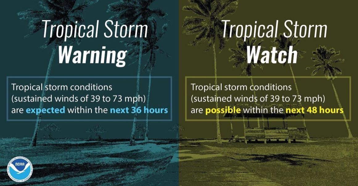
What is a Tropical Storm Watch / Warning?
Tropical Storm Watch and Warning refer to a time based issued alert on when Tropical Storm (TS) force sustained winds (39-73mph; 63-117km/h; 34-63knots) are possible or expected in the Watch/Warning area.
Tropical Storm Watch: TS winds possible within 48 hours or less.
Tropical Storm Warning: TS winds expected within 36 hours or less.
Note: A Warning in weather means occurring or imminent, to take action immediately.
For the United States these Watch or Warnings are issued by the US National Hurricane Center (NHC) while in other countries the weather alert may be issued by the local government or weather service. The current Watch/Warning locations can always be found on the NHC's website, under 'Public Advisory' for an active storm on their homepage, just below the main weather map.
While a Hurricane 'cone map' may say a storm arrives at a location around a certain time, that is only referring to the center of a storm. Hurricanes are large systems, typically several hundred miles in diameter, and Tropical Storm winds are likely to arrive well in advance of the center / eye.
Residents should be fully hunkered down in their designated safe spot by the time Tropical Storm winds arrive, as winds of just around 40mph starts bringing down trees and power lines along with Storm Surge potentially cutting off routes of escape (See Storm Surge Watch/Warning & Storm Surge sections for additional information on that subject).
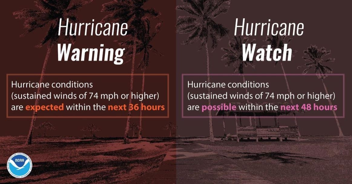
What is a Hurricane Watch / Warning?
Hurricane Watch and Warning refer to a time based issued alert on when Hurricane force sustained winds (74mph or greater (119km/h+, 64knots+) are possible or expected in the Watch/Warning areas.
Hurricane Watch: Hurricane force winds possible within 48 hours or less.
Hurricane Warning: Hurricane force winds expected within 36 hours or less.
Note: A Warning in weather means occurring or imminent, to take action immediately.
For the United States these Watch or Warnings are issued by the US National Hurricane Center (NHC), while in other countries the weather alert may be issued by the local government or weather service. The current Watch/Warning locations can always be found on the NHC's website, under 'Public Advisory' for an active storm on their homepage, just below the main weather map.
While a Hurricane 'cone map' may say a storm arrives at a location around a certain time, that is only referring to the center of a storm. Hurricanes are large systems, typically several hundred miles in diameter, and Hurricane force winds may arrive well in advance of the center / eye. Residents should be fully hunkered down in their designated safe spot by the time Tropical Storm force winds (39-73mph) arrive, as winds of just around 40mph starts bringing down trees and power lines in the United States along with Storm Surge potentially cutting off routes of escape (See Storm Surge Watch/Warning & Storm Surge sections for additional information on that subject).
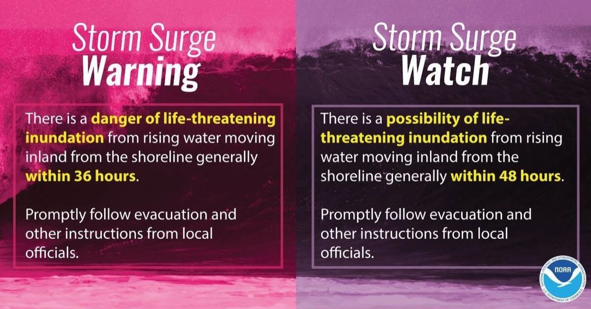
What is a Storm Surge Watch / Warning?
Storm Surge Watch and Warning refer to a time based issued alert on when Storm Surge is possible or expected in the Watch/Warning areas. They are generally only issued when water levels may rise 3ft (1m) or higher. Storm Surge height is dependent on several factors (detailed in ‘Storm Surge’ FAQ) but in the United States can top out around 30ft (9m) (The highest recorded in the United States was Katrina (2005) with 28ft into Mississippi).
Storm Surge Watch: Possibility of life-threatening inundation(water above normally dry ground moving inland) within 48hours or less.
Storm Surge Warning: Danger of life-threatening inundation(water above normally dry ground moving inland) within 36hours or less.
Storm Surge flooding can begin several hours or even days before a Tropical Cyclone makes landfall, cutting off escape routes early on. If told to evacuate, do so immediately.
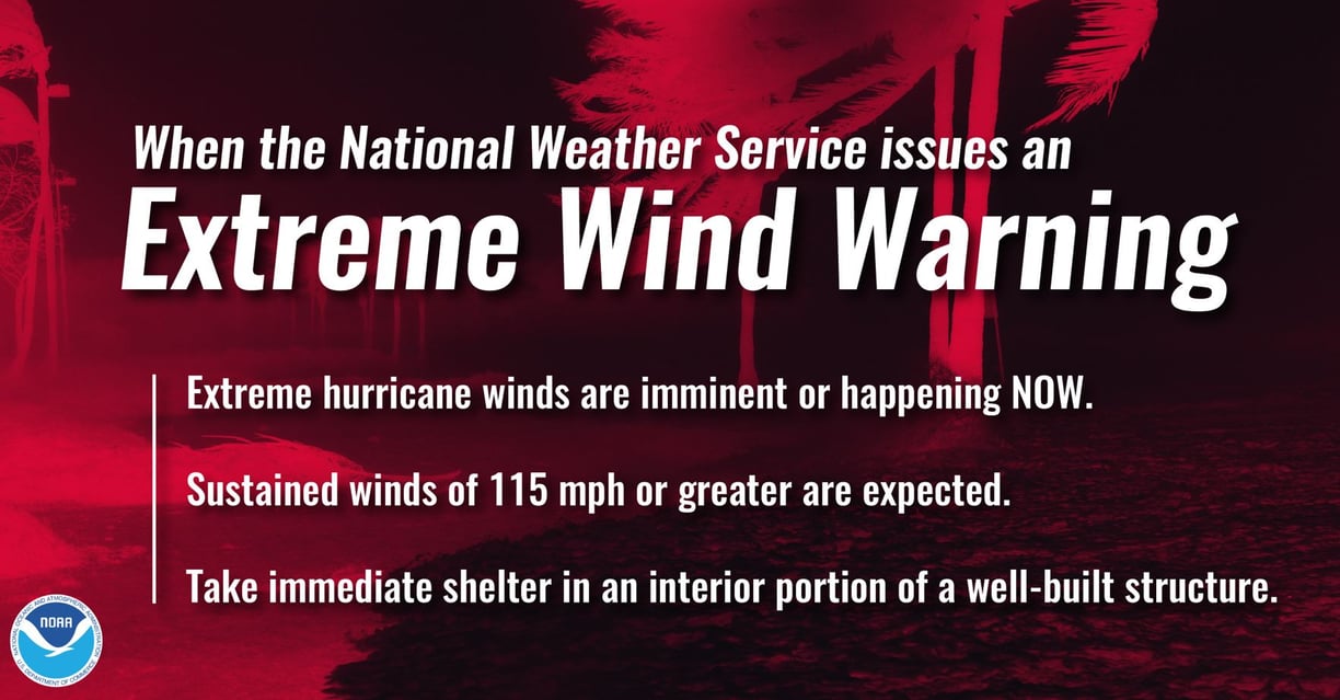
What is an Extreme Wind Warning?
Issued when sustained winds of 115mph+ (185km/h+; 100knots+) are expected or are occurring over land due to a more intense Major Hurricane at landfall, typically for areas near the central eye wall. This Warning should be treated like a Tornado Warning, seeking immediate shelter in the lowest most interior room away from windows with as many walls between you and the outside as possible and may last for several hours.
What is a Flood Advisory?
A Flood Advisory is generally issued when some flooding is possible or likely occurring that's considered more nuisance flooding than anything else. Water may cause an inconvenience when going about one's day. Be careful near ditches and rivers especially where swift moving water is occurring. If not careful and not paying attention, water could result in threat to life and/or property.
What is a Flood Watch / Warning?
A Flood Watch means conditions are favorable for Flooding to occur at some point, generally during the Watch time period or rainfall event. It does not mean flooding will occur, just that it can. Know what you would do should a flood warning be issued.
A Flood Warning means flooding is imminent or occurring. Seek higher ground, but do not drive through flooded roadways to get there. #TurnAroundDontDrown - The majority of US flood related deaths are vehicle related. As little as 12 inches (30cm) can move a car. Vehicles can stall out in flood waters due to water entering the air intake, exhaust tail pipes, and even just reaching the bottom floor boards of vehicles where sensitive and expensive computers that run the vehicle are typically kept.
In Tropical systems water is the biggest killer on average for the US. Tropical cyclones can dump several inches per hour rainfall rates and can stick around from just a few hours to a few days. Rain is typically measured in inches but sometimes even feet! Hurricanes are large, covering several hundred miles. These large scale weather events can make it difficult or even impossible to close every flooded roadway.
What is a Flash Flood Warning?
A Flood Flood Warning means a flash flood is imminent or occurring. Flash flooding is the sudden, sometimes violent, flooding of a specific area or region. Flash flooding can occur even if it is not raining at your location. Seek higher ground, but do not drive through flooded roadways to get there. #TurnAroundDontDrown - The majority of US flood related deaths are vehicle related. As little as 12 inches (30cm) can move a car. Vehicles can stall out in flood waters due to water entering the air intake, exhaust tail pipes, and even just reaching the bottom floor boards of vehicles where sensitive and expensive computers that run the vehicle are typically kept.


What is a Flash Flood Emergency?
Flash Flood Emergency is issued in rare cases where flash flooding is occurring or likely to occur soon where catastrophic damage is possible and threat to human life. Water rescues from vehicles and buildings can be expected under dangerous conditions.
What is a Tornado Watch / Warning?
Tornado Watch: Ingredients for a Tornado are there, know what you would do should a Warning be issued. Have a plan for each place you’ll be visiting and while in transit.
Tornado Warning: Tornado occurring or imminent, take shelter immediately!! During a Warning, seek immediate shelter in the lowest most interior room away from windows with as many walls between you and the outside as possible. Pulling blankets, pillows, mattresses over and around you or even a bicycle helmet can help in case damage to the house occurs.
In Tropical systems affecting the US, tornadoes are most common in the Northeast quadrant (corner) of the storm as outer rainbands rotate inland. Tornadoes will generally follow the movement direction of the rain band it’s embedded in. This may result in tornadoes traveling in directions not typically seen by tornadoes generated by other weather systems. Tornadoes associated with tropical cyclones generally are very brief, weaker variety and short lived popping up and disappearing about as quickly as they form. There are a few exceptions though where longer track and much more powerful tornadoes can sometimes be spawned by a Hurricane.
Tornado sirens are scattered around the US here or there, but they are not controlled by the National Weather Service who issues a Tornado Warning. Instead they are controlled by local officials who may activate them in just the area being warned or county wide. More modern built homes typically cannot hear tornado sirens which are older World War II air raid siren technology repurposed.


Watch versus Warning graphic to help illustrate the difference. Graphic by @wxBrad (Twitter).
Who issues Watch / Warnings?
For Tropical Cyclones in the Atlantic, Central and East Pacific basins, the US National Hurricane Center (NHC) issues Tropical Storm, Hurricane and Storm Surge Watch and Warning products. For other nations in these basins the respective government or local weather service will issue Watch and Warning products or will be issued by the NHC on their behalf.
For other weather products in the United States (tornado, flood, etc), Watch and Warning products are issued by the US National Weather Service (NWS). These alerts are then pushed to local news, radio, apps and other media to alert the general public (see our ‘Receiving Weather Alerts’ section for more information). The NHC and NWS both fall under the umbrella of NOAA and the US Department of