
Hurricane FAQ
Frequently Asked Questions
Terminology
Just because it spins - doesn't mean it's Tropical
Jump To:
Cyclogenesis
What is...
Eye
Eyewall
Secondary Eyewall
Moat
Rapid Intensification (RI)
Quadrant
Right Front Quadrant
Wobble
Trochoidal Oscillation (Wobble)
Brown Ocean Effect
Central Dense Overcast (CDO)
Pressure (mb)
Pressure Gradient
Stadium Effect
Mesovortices (in eye)
What is Cyclogenesis?
Tropical cyclogenesis is the birth of a Tropical Cyclone. Typically this would be where water temperatures of 26.5 degrees Celsius (79.7 F) or higher (Subtropical Storms can form at lower water temperatures).
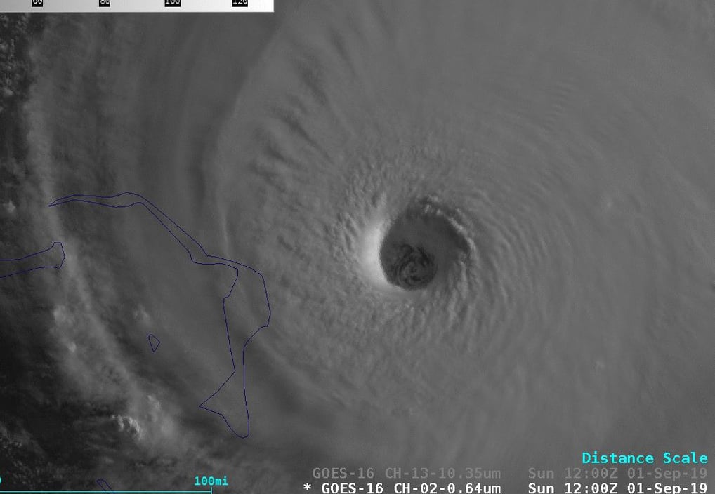
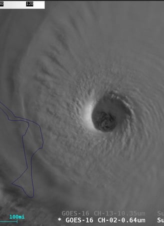
What is the Eye of a Hurricane?
The 'Eye' refers to the center of a tropical cyclone that is usually found to be cloud and storm free when well developed. Conditions in the eye can sometimes be completely calm and clear skies. But don't be fooled by this sudden break in the storm as one of the most dangerous parts of a hurricane, the eyewall, surrounds it. It is typically more defined in stronger storms. A clouding over of the eye or less sharply defined eye can signal weakening or a weaker system. The center of the eye usually contains the area of lowest pressure which is considered the storm's center location point. Distances of how far away a storm is from land are from this point. A tropical system is declared to have made ‘landfall’ when this center point crosses land.
Note: See ‘What are Mesovortices’ in the eye’ for additional information.
What is the Eyewall?
The eyewall refers to the center ring of storms that surrounds the 'eye'. In a well developed cyclone this region will have the strongest sustained wind and wind gust. This area can be just a couple miles to several miles wide. This ring can be clearly seen on weather radar when within range.
What is a Secondary Eyewall?
Similar to the main eyewall, a secondary eyewall is another ring of intense convection (storms) and winds, typically near or equal in strength to the adjacent main eyewall with a small break or lessening of winds and storms in between them. The secondary eyewall is found outside of the first. Its presence usually indicates an Eyewall Replacement Cycle (ERC) is underway where the secondary eyewall eventually takes over as the main eyewall, absorbing the inner one as it contracts. A cyclone typically levels off in intensity while this occurs or even weakens slightly over this several hour process. The end result is typically a larger eye then the first eyewall allowed, a broader reach of maximum winds and, like changing the batteries on a toy, the storm is then free to once again strengthen.
What is the Moat?
The moat in a hurricane often refers to a gap or break in winds and rain between rain bands. It generally features calm conditions. While it can give a temporary reprieve from storm conditions one should be careful to not get caught outside as the next rain band or central eyewall may hit suddenly with little to no warning.
What is Rapid Intensification (RI)?
Rapid Intensification (RI) is defined as an increase in sustained winds of a Tropical Cyclone by 35mph (30knots) or more within a 24-hour period. Forecasting the intensity of a Hurricane is typically more challenging then predicting its path. Of the few Category Five’s that have struck the United States, the majority were Tropical Storms just 72 hours prior to landfall. There are several factors that can lead to a rapid intensification scenario including low wind shear, warm ocean water temperatures, good outflow, etc.
What is a Quadrant?
Tropical Cyclones can be divided up into four equal slices known as quadrants. Think of a pie cut into just four equal parts. This can give you the Northeast, Southeast, Northwest and Southwest quadrants (pie slices).
Note: See ‘Right Front Quadrant’ below for additional information and impacts
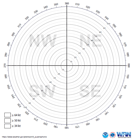
Quadrant graph divided into Northeast(NE), Southeast(SE), Northwest (NW), and South West (SW) quadrants. (Image source: NWS JetStream)
What is the Right Front Quadrant?
The Right Front Quadrant location in a Tropical Cyclone varies based on the forward directional movement of the system. For example, if a Hurricane were heading due North then the right front quadrant would be the Northeast corner (or quadrant). If heading due West then the right front quadrant would be the Northwest quadrant. The right front quadrant is basically the passenger seat of a moving car, always just to the right of center, towards the front, and heading in the direction the vehicle, or in this case storm, is traveling. The right front quadrant typically sees the greatest storm surge impact due to onshore winds. It also typically contains the strongest winds and greatest region of tornado risk.
What is a Wobble?
Hurricanes typically don't move in a straight line even though traditional cone maps or past track maps tend to show this. When viewed up close on radar or satellite the storm can be seen to actually wobble back and forth as generally moves forward (similar to a car along the roadway may stay in its lane but drifts closer to the left line or line on the right repeatedly). When nearing land at an angle, sometimes a storm will wobble down the coast slightly as it interacts with the nearby land (whether by friction of storms slowing over land or other reasons). In forecasting storms it should be noted that a slight wobble of say just half of a degree doesn't sound like much, but when the storm must cross hundreds of miles to reach land a little wobble here or there could potentially mean the difference between receiving the eye and storm surge and just being brushed by the system.
Note: see ‘What is a Trochoidal Oscillation (Wobble)?’ for additional information.

What is Trochoidal Oscillation (Wobble)?
Trochoidal Oscillation is another form of wobble but signifies a secondary eyewall is present. This is more common in stronger tropical cyclones. The wobble can typically be seen on weather radar and satellite. While the system moves generally in the same direction, it’s as if the storm is bouncing off walls back and forth.
Track of fixed point on rolling barrel example. (Image source: Wikimedia)
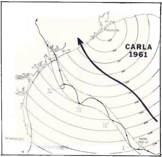
Example center track of a tropical cyclone (Carla, 1961) with trochoidal oscillation movement.. (Image source: NOAA adaptation from Weatherwise, October 1961)
Example of Hurricane Wilma (2005) performing trochoidal oscillation movement. (Image source: NOAA)
What is Brown Ocean Effect?
Brown Ocean Effect is a term used for Tropical Cyclones that maintain or actually intensify after making landfall (come ashore) or while over land. This can be because a storm is nearing another warm water source and starts drawing energy, moves over more expansive areas of warm water marsh lands or areas with higher saturated grounds from recent rains, other nearby weather systems help enhance the storm, or other factors.
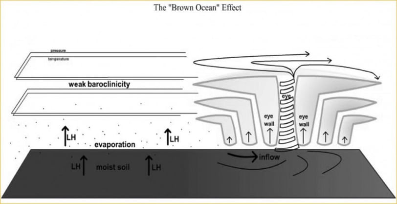
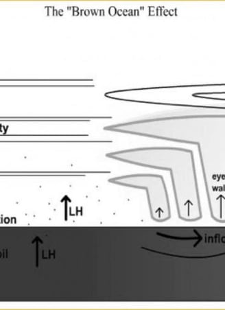
Brown Ocean Effect figure. (Image credit: Dr. Theresa Andersen and Dr. Marshall Shepherd / University of Georgia)
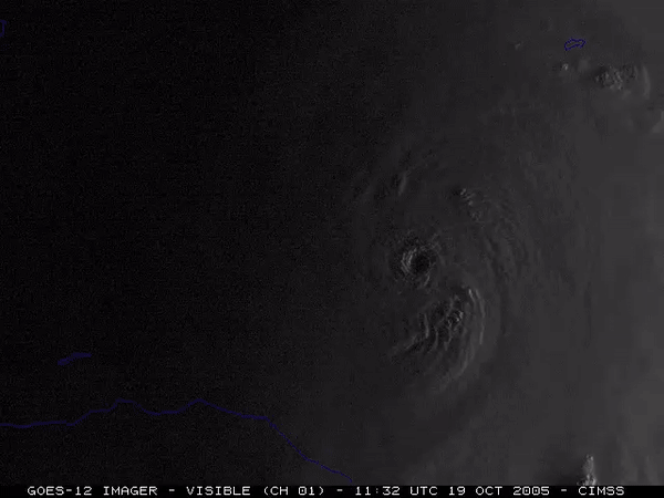
In 2021 Hurricane Ida refused to weaken for several hours once it came ashore into southern Louisiana, likely feeding off of its own storm surge over low lying terrain and expansive marsh and swamps. A 2016 example is of a Tropical Depression that made landfall near Jensen Beach, FL, then moving just inland and parallel to the FL coast strengthened into 50mph (80km//h) Tropical Storm Julia before moving offshore, likely feeding off of the nearby Atlantic Ocean. In 2007 Tropical Storm Erin made landfall near Lamar, TX quickly weakening to a Tropical Depression. Three days later upon entering Oklahoma, Erin intensified with winds of 60mph (97km/h) with higher gusts, with an eye clearly visible on radar and banding features.
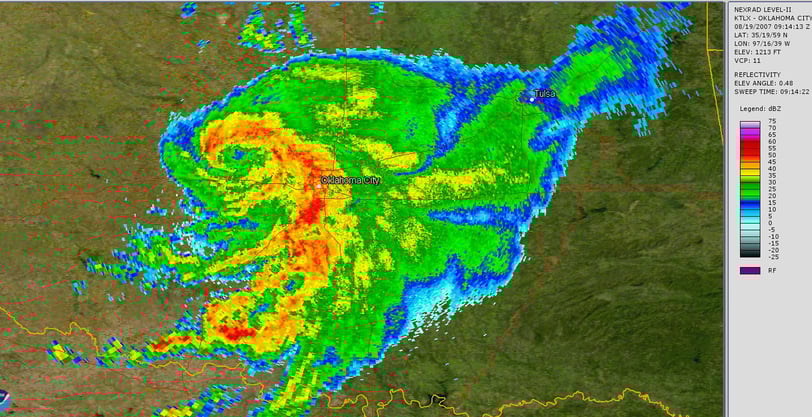
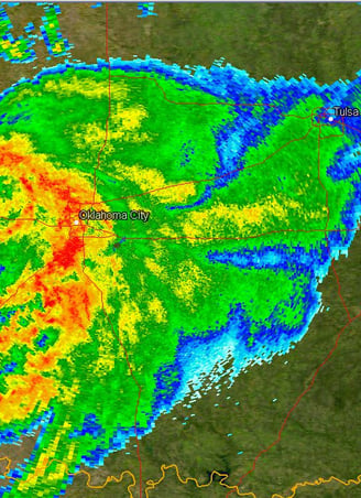
Weather radar image of Tropical Storm Erin (2007). (Image credit: NOAA)
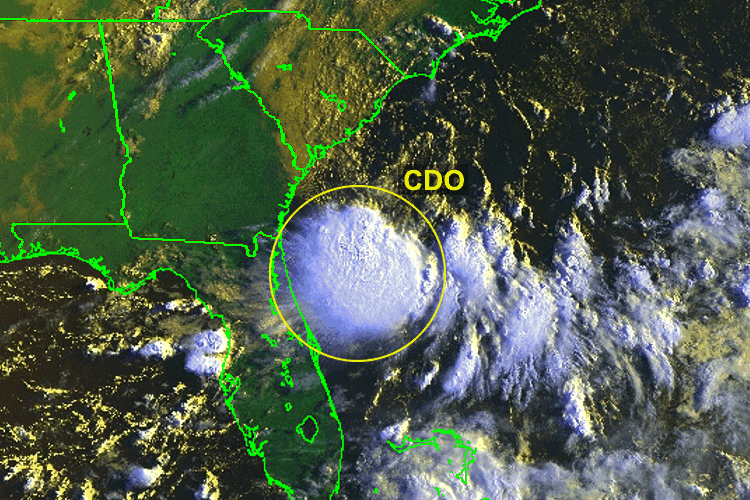
What is a Central Dense Overcast (CDO)?
The Central Dense Overcast (CDO) is the region of high cold cirrus clouds over the central core of a tropical system. In younger tropical systems the CDO may obscure the center / eye on visual imagery, eventually clearing as the storm intensifies revealing the eye. In healthy young systems the CDO may be symmetrical.
Satellite imagery showing healthy CDO over Tropical Depression that would later become Hurricane Alex (2004). (Image from: Penn State Dept. of Meteorology)
What is the Stadium Effect?
When standing in the eye of a well structured or powerful Hurricane, the clouds on the edge of the eyewall region may resemble that of a sports stadium, with the clear center of the eye like the field and the clouds the seats of the stadium angling upwards and out.
Sunlight and shadows help reveal the stadium or cone like shape of clouds of the eyewall in Hurricane Dorian (2019). (Image credit: NOAA)


View from inside the eye of Hurricane Epsilon (2020). (Image credit: USAF Hurricane Hunters)
What does Pressure (mb) represent?
Pressure values often accompany current or historical Hurricane data. This atmospheric pressure data is listed in ‘mb’ (millibars) units. Like most storm systems, the lowest pressure value is found in the center core area, in this case the eye or center point of a hurricane and a higher pressure the further from that point you are. The pressure values of tropical cyclones do not correlate one to one with wind speed, but in general a pressure value likely means the wind speed of a storm can be expected to be around a certain range. Pressure is monitored in tropical cyclones as the pressure change usually occurs and then the wind speed change follows. A dropping pressure typically means the storm is strengthening and winds will likely continue to increase. A rising pressure usually precedes a weakening storm system. The rate at which a pressure changes can also be an indicator on how fast the winds may change. It is a valuable tool in monitoring and predicting hurricanes across the globe.
The atmospheric pressure is often given with each Hurricane update advisory or nearly constantly if Hurricane Hunters are flying around or through a storm system taking measurements. It is a number listed in ‘mb’ units (Millibar). The pressure is important in hurricane forecasting as it is a leading indicator of what the storm may do next in terms of wind speed. As the pressure value falls winds will typically increase within a few hours, as the pressure rises winds will decrease. A steady pressure typically results in steady winds.
What is a Pressure Gradient?
An Extratropical Cyclone is a type of Post-Tropical Cyclone, a system that has lost it’s Tropical Cyclone characteristics (but still may be a powerful Hurricane like system). These systems generally have a poleward motion and derive its energy from baroclinic processes (temperature difference between warm and cool air).


What are Mesovortices (in the eye)?
Remnant Low’s are a type of Post-Tropical Cyclone, generally referring to a system that has lost deep convection and no longer meets the definition of a Tropical Cyclone. This is more commonly seen when a Tropical Cyclone has undergone high wind shear, blowing storm tops away leaving just a swirl of harmless spinning clouds with winds less than 39mph (63km/h; 34knots).