
Hurricane FAQ
Frequently Asked Questions
Hazards / Impacts
Just because it spins - doesn't mean it's Tropical
Jump To:
Main Hazards / Impacts
More hazard / impact information on...
Storm Surge
Inland Flooding
Tornado
Wind
Tree
Electricity
Landslide / Mudflow
Rip Currents
PTSD


What are the main Hazards / Impacts in Hurricanes?
Hurricanes can leave lasting impacts from weeks, months, to even years later, in some cases forever changing whole communities. Hurricanes contain multiple hazards both near and far from the storm center. These can include Storm Surge, inland flooding, winds, falling trees and power lines, rip currents, unable to reach medical services, cleanup accidents, etc. (See below for more details on each).
What is Storm Surge?
Storm Surge is the rise in water above normal tide levels due to a storm system moving into the region or near the coast. Similar to high or low tides, surge is the entire body of water rising with waves on top. It can move many miles inland, inundating areas far from the coast line, cutting off avenues of escape, bringing down buildings, bridges, etc. It is the most deadly aspect of a Hurricane in the United States, accounting for roughly half of all deaths in landfalling systems on average. In order to help prevent this, evacuation zones are mainly based on storm surge levels. Although some refer to it as a tsunami, this is not the case, but the aftermath can resemble one.
The highest recorded Hurricane storm surge in the United States was ‘Katrina’ (2005) bringing 28ft (8.5m) to the Bay St. Louis & Pass Christian, Mississippi region with coastal flooding reaching 6-12miles (9.5-19km) inland.
Although each storm is different, surge height generally grows the stronger the storm is. Surge is typically highest in the Right Front Quadrant area near the eye and becoming less the further away you are from there. It can affect hundreds of miles of coast line, even with no severe weather present and sunny skies. It’s important to head any evacuation orders given. You cannot wait until “it starts to get bad” before deciding to leave as it will likely be too late and risk getting caught in flood waters away from home with no one knowing your exact location and risk the lives of those trying to save you.
Some areas are more vulnerable to surge then others. This is mainly due to the depth of water and shape of the coast line. In areas where waters are deeper along the immediate coast, surge is typically less to nearly non-existent, such as Eastern Taiwan or West Palm Beach, FL regions. In areas with shallow coast such as Southern Louisiana or Southeast GA, surge risk can be an immense danger. The majority of US coast have comparatively shallow waters making them vulnerable to storm surge.
As a Tropical Cyclone approaches the Ocean water level begins to rise, similar to a high or low tide cycle. This can begin hours or even days before landfall or storm passing nearby. This rise may be enough to start cutting off road access to low lying regions especially during times of high tide. This gradual rise may change to a more sudden rise and rush in water as the center of a storm approaches land and makes landfall. It comes in from the Ocean, into Bays, up rivers and other waterways. Depending on city infrastructure surge can even travel up storm drain systems. Surge is generally higher where onshore wind direction is occurring. North of the equator a Cyclone spins counter clockwise bringing onshore winds generally on the forward right side of the eye pushing water inland and offshore winds on the left pushing water out. As the storm continues to move by, these winds begin to shift, changing where the push of water is occurring. A notable example of this is the Outer Banks of North Carolina where a storm moving through the region can first bring coastal flooding from surge to the Ocean side of the barrier islands. Then as the storm passes winds shift bringing flooding to the Sound side which can have less protection then the sand dune lined beach front areas, sometimes causing greater damage as the storm departs. Until Storm Surge Watch or Warnings are discontinued, the threat may remain.
Surge height can vary greatly over short distances. Water heights can be affected by many factors including strength of storm, direction and angle of storm approach, movement speed of storm, physical size and structure of storm, tide state, coastal shelf depth, and even shape of the coast line. Coastal regions that resemble a bowl or the arc can enhance water levels (such as Bulls Bay, SC, Chesapeake Bay, VA and Tampa, FL).
The tidal state can have a great impact on surge, even in smaller systems. A storm hitting at low tide versus high tide can look very different even with the same level of surge. For example, a storm hitting with a 3ft (1m) surge into an area where the normal difference in water height between high and low tide is already 3ft then the surge arriving at low tide would resemble a normal high tide level. But if the storm hit at high tide then the 3ft added would push the water up past its normal tidal boundary, potentially flooding homes and businesses, as well as cutting off road access. Since surge is the rise in water above normal tide levels the tidal effect can mean the difference between water levels just looking like a normal high tide or water into homes and businesses. You can’t just say it didn’t flood last storm. Every storm is different. If told to evacuate, do so!
There are planning tools to determine your surge risk in the United States, Puerto Rico, US Virgin Islands and Hispaniola. During a Tropical Cyclone, Storm Surge Watch and Warnings will be posted starting 48hrs prior to Storm Surge of 3ft (1m) or higher. Once this occurs an interactive surge map specific to that Tropical Cyclone will also be released showing probable surge heights (see ‘How to read NHC products’ FAQ for more detailed information and release times). The other tool is an interactive Storm Surge hazards map available year round in order to determine and plan for storm surge risk (see ‘How to read NHC products’ FAQ for more detailed information and link).
Is Inland Flooding a concern in Hurricanes?
Tropical Cyclones can dump a tremendous amount of rain causing widespread and devastating impacts. Inland freshwater flooding from tropical cyclones in the US is the second leading cause of deaths among landfalling hurricanes. Do not attempt to drive through flooded roadways nor drive around road closure barriers. In large scale disasters first responders and road crews will not have the time or equipment to close and monitor all flooded roadways. The majority of US flood deaths are vehicle related.
What are the Tornado risk in Hurricanes?
Briefly lived, quick to spin up tornadoes can be common in landfalling Tropical Cyclones. Occasionally larger long lived tornadoes can form, but most are not. In landfalling tropical cyclones they are mostly found in the right front quadrant as rain bands spiral in and start to rotate the atmosphere with friction from the land. As storms make their way further inland, sometimes long feeder bands can develop back towards the water such as when a Hurricane makes landfall into the US Gulf of Mexico coast and heads up towards the Northeast US. This feeder band reaches back down towards the Gulf or Atlantic waters where tornadoes can also develop.

What are the dangers of Winds in Hurricanes?
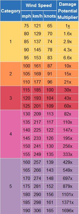
Like earthquakes, wind damage is exponential. For example, if winds from a Cat1 Hurricane with winds of 75mph (121km/h) were doubled to Cat4 with 150mph (241km/h) winds the damage is not double, but is around 256 times more.
Wind damage potential multiplier scale chart. (Image source: NWS JetStream)
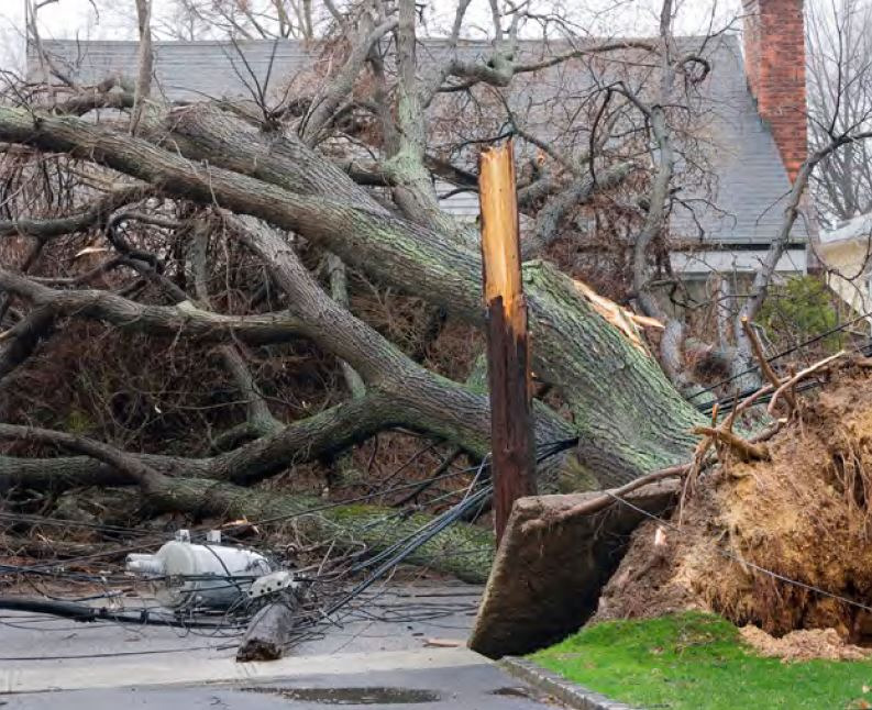
What are the Tree risk in Hurricanes?
It only takes winds of around 40mph (64km/h) to start bringing scattered trees down, especially when grounds are saturated. Many times those in the path of a relatively weaker Tropical Storm are caught off guard that a low end Tropical Storm can bring down trees especially when they have witnessed stronger winds in thunderstorms. The wear and tear over many hours in a tropical cyclone can start to cause many problems, especially with trees. Tropical cyclones, being hundreds of miles in diameters, can have far reaching effects on trees and other vegetation even when far away from the main core winds.
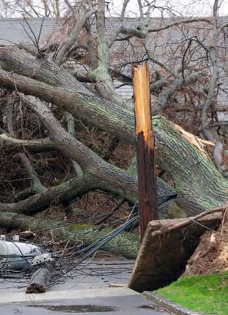
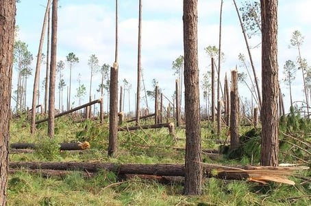
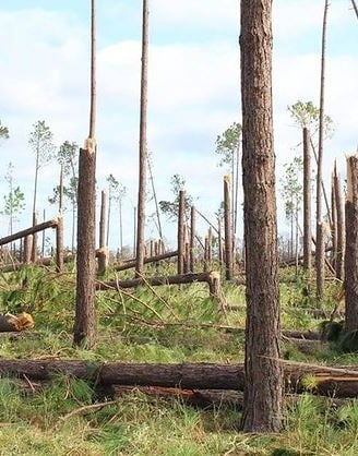
Large number of trees snapped after Hurricane Michael (2018) (Image source: Florida Forest Service)
Large number of trees snapped after Hurricane Michael (2018) (Image source: Florida Forest Service)
What are some of the Electrical hazards in Hurricanes?
Winds of just 40mph or so are enough to start causing scattered power outages in the United States. More intense Hurricanes can cause power outages that last weeks or even months. Above ground power lines are susceptible to trees and branches falling which can come down at just around 40mph winds. Wear and tear over several hours of moving power lines in winds can weaken and eventually break electrical connections or flooding can lead to failures or shutdowns of substations or other electrical boxes at ground level.
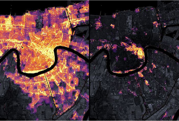
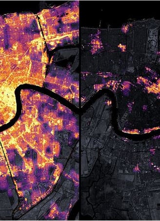
New Orleans region satellite view of city lights (left) and after Hurricane Ida knocked out power to most of the region (right) (Image source: NASA)
What are the Landslide / Mudflow concerns?
Tropical systems can dump an immense amount of rainfall over relatively short time periods. This can lead to landslides and mudflow.
What can the Rip Current risk be?
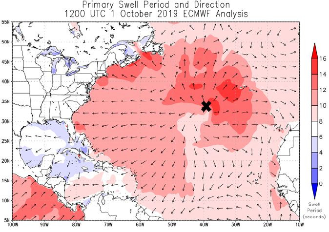
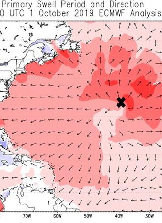
Tropical cyclones present a real hazard to beach goers, even from over 1,000miles (1610km) away and on sunny calm weather days. Calm weather can fool many at the beach into thinking there is no danger. When Hurricane Lorenzo was over 2,000miles off the US East coast, the storm was still able to cause rip currents across the US Eastern seaboard resulting in 8 deaths
Swells map showing Hurricane Lorenzo(2019) (represented by the black ‘X’) generated swells across the Atlantic (Image source: ECMWF wave model analysis via US National Hurricane Center after storm report)
Can Hurricanes really induce PTSD?
Hurricanes can last for many hours to a full day or more over a single point. This prolonged wear and tear on the senses and property, the endless noise of the wind, no breaks, no stepping out for a coffee to relax, along with endless news and social media coverage, not only starts to break down infrastructure, but also the human mind. Post-Traumatic Stress Disorder (PTSD) has been associated and documented with Tropical Cyclones. Causes can be related to, but not always include, prolonged stress awaiting storm, during storm, or dealing with the aftermath. Financial difficulties, finding food and water for the family, seeing death or injuries or hearing of lost loved ones, the seemingly endless sounds of wind and debris, lack of communication, delays in finding or alerting first responders, uncertainty, and other factors of large scale disasters, etc.
Having a plan in place prior to the start of Hurricane Season can help with stress and anxiety with storms. When would you evacuate? When told by officials? If the storm is Cat1 or higher? If could lose power? What would you take with you? Where would you go? How can you get there? What about your pets? Answering these questions now before a storm approaches and acting on that plan when the time comes, without hesitation, can markedly improve outcomes. Being calm in front of children in the household can also have an impact on their well being too.
If you or someone you know may be suffering from PTSD due to a Tropical Cyclone, seek assistance. You are not taking away from someone else by seeking help. It’s ok, and you are not alone.