Hurricane Hunters
Yes they really fly into Hurricanes!
Jump To:
Live Recon Data
Schedule
About the Aircraft
Equipment Used
Stock Images/Video
History
Other Aircraft
"The information collected makes possible advance warning of hurricanes and increases the accuracy of hurricane predictions and warnings by as much as 20 percent" -USAF 403rd Wing
Live Recon Data
Visual Data Feeds:
Live data is transmitted in raw text format but websites such as these help display that data with maps, colors and more. Check dates/time to verify if latest run.
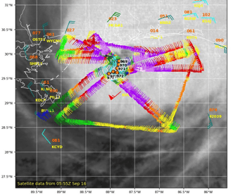
Tropical Tidbits
Hurricane City
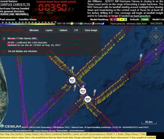
(Select flight top left corner)
-OR-
Track Flight Path by Tail Number:
While no storm data, you can still sometimes see their flight paths via your app or website of choice. Search for the following tail number shown in "quotations". Note dates & time on page.
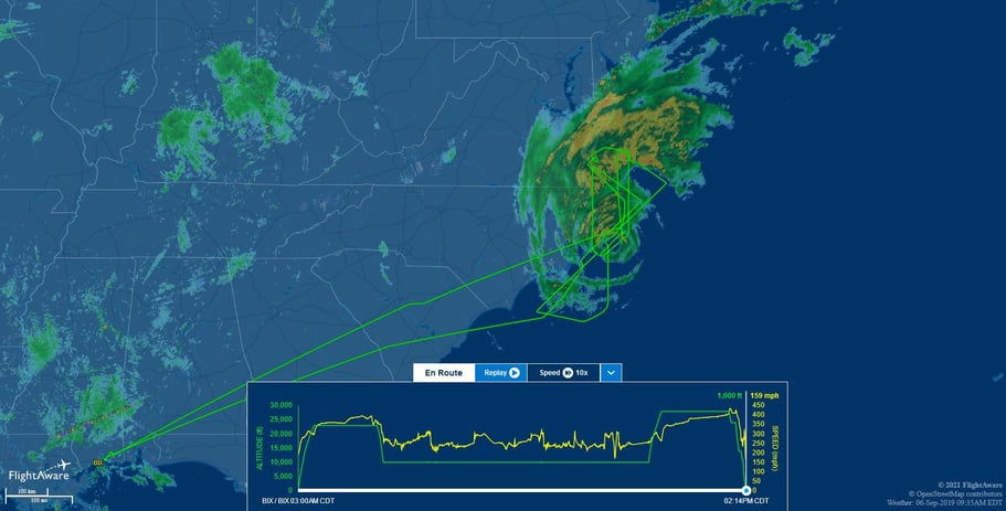
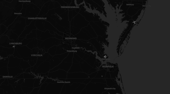
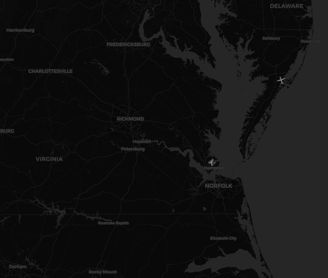
FlightAware track of Teal71 during "Dorian" 6 Sept. 2019


Tip: The tail number will be listed on the daily 'POD' (See 'Schedule' below, subject to change)
Schedule
Find when and where USAF and NOAA planes will fly into storms
NHC issues two schedules: For Today & For Tomorrow
Typically released daily around 11amEDT+/-
Plans may be modified at any time due to change in storm, mechanical issues, weather, etc.
Areas covered: Atlantic, Central & East Pacific
Today's Plan (released day before):
Tomorrow's Plan (released today):
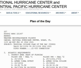
How to read Plan of the Day
Example format when flights scheduled, key points in Bold:
********Sample Text Start********
Note: Time in 'Zulu' which is four hours ahead of EDT (ie: 1230Z = 830amEDT)
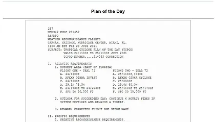
000
NOUS42 KNHC ######
REPRPD
Weather Reconnaissance Flights
CARCAH, National Hurricane Center, Miami, FL.
1145 am EDT Wed 16 June 2021 (Time and date last updated)
Subject: Tropical Cyclone Plan of the Day (TCPOD)
Valid: 17/1100Z to 18/1100Z June 2021 (Dates and time covered in schedule)
TCPOD Number.....21-###
I. Atlantic Requirements
1. Subject Area (Off Southeast US coast) (Storm name or general area)
Flight One - NOAA 49 (Plane number: NOAA ## = NOAA, Teal ## = USAF)
A. 17/1730Z (Storm fix(location) date/time)
B. AFxxx 01AAA Invest (Mission ID)
C. 17/1515Z (Departure date/time)
D. 21.0 N 93.0W (Fix/Storm forecast coordinates)
E. 17/1700Z to 17/2200Z (Dates/time in storm)
F. Sfc to 10,000ft (Altitude range in storm)
G. (Optional comments)
2. Outlook for succeeding day: Continue 6-hourly fixes if system develops (How often new flights to be scheduled)
II. Pacific Requirements
1. Negative reconnaissance requirements
********Sample Text End********
Additional info: https://www.nhc.noaa.gov/recon.php
About the Aircraft
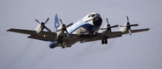
NOAA Aircraft:
https://www.omao.noaa.gov/learn/aircraft-operations/about/hurricane-hunters
Based out of: Lakeland, FL - Linder Regional Airport
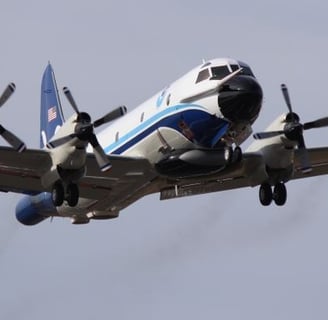
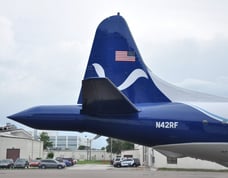
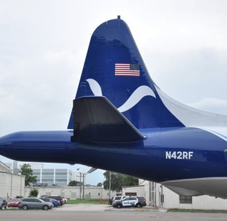
Lockhead WP-3D Orion: N42RF "Kermit" & N43RF "Miss Piggy"


Photo: Lt. Cmdr. Mitchell, NOAA Corps, N42RF "Kermit" (to left), N43RF "Miss Piggy" (to right), St. Croix Sept. 18, 2020
Four engine turboprop
Deploys GPS Dropwindsondes
Deploys Coyote UAV
Deploys Bathytherograph (AXBT)
Three weather radars
Step Frequency Microwave Radiometer (SFMR)
Precipitation and cloud particle probes
Crew: 8 to 21
Max Range: (altitude dependent)
2,500 - 3,800 nautical miles
2,877 - 4,373 miles
Max flight time: 9.5 - 11.5 hours (altitude dependent)
Wing span: 99'-8" (30.4 Meters)
Length: 116'-10" (35.6 Meters)
Ceiling: 27,000ft (8,230 Meters)
Built: 1975 (N42RF), 1976 (N43RF)
Planes in service: 2 (N42RF, N43RF)
Hurricane missions: Fill in radar and satellite data gaps via low altitude data collection in and around storms.
General weather missions: Study and record data of Earth's atmosphere and environment in support of monitoring hurricanes, severe weather, oceanographic, atmospheric and climate trends.
Gulfstream IV-SP (G-IV): N49RF "Gonzo"


Photo: Tim Smith, N49RF "Gonzo", Portland, OR International Airport 2020
Twin jet engine
GPS Dropwindsondes
Tall weather radar (TDR)
Crew: 8 to 9
Planes in service: 1 (N49RF)
Max range: 3,600+ nautical miles (4,143+ miles)
Max flight time: 8.75+ hours
Wing span: 77'-10" (23.7 Meters)
Length: 87'-7" (26.7 Meters)
Ceiling: 45,000ft (13,716 Meters)
Built: 1994
Hurricane missions: Sample upper atmosphere around and above tropical systems.
General weather missions: High altitude observations of weather systems in upper atmosphere.
Gulfstream 550: Currently in Testing, Operational sometime 2024


Photo: Gulfstream
Twin jet engine
Max Range: 6,750 nautical miles (7,768 miles)*
Wing Span: 93'6" (xxxx Meters)
Length: 96'5" (xxx Meters)
Ceiling: 51,000ft (XXX Meters)
Built: 2022
*Range will depend on final modifications and equipment loaded.
Mission: Similar to G-IV N49RF with high altitude observations of weather systems in upper atmosphere sampling around and above tropical systems.
USAF Aircraft:
Based out of: Biloxi, MS - Keesler Air Force Base
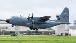
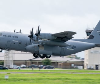
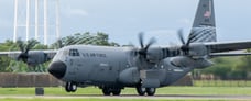
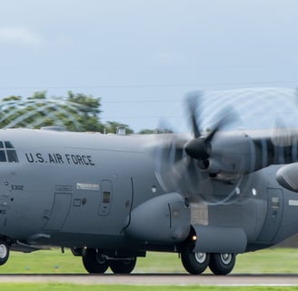
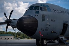
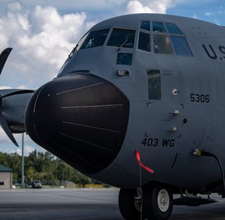
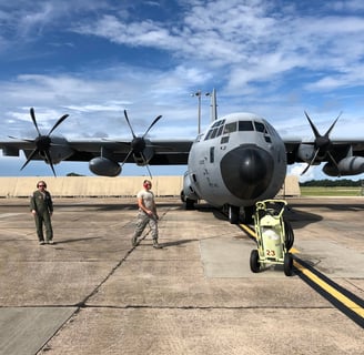
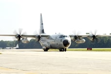
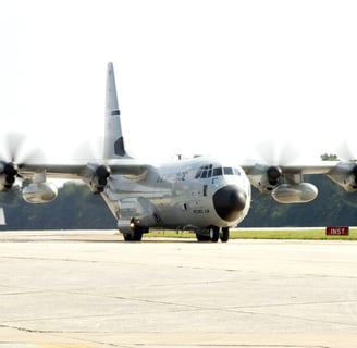
Lockhead WC-130J:

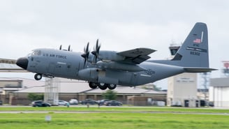
Photo: Staff Sgt. Kristen Pittman, WC-130J Super Hercules, Keesler AFB Biloxi, MS July 6, 2021
Four engine turboprop
Deploys GPS Dropsondes
Step Frequency Microwave Radiometer (SFMR)
Crew: 5
Planes in service: 10 (Teal70 through Teal79)
Average weather mission: 11 hours
Max flight time: 18 hours
Average weather mission range: 3,000 nautical miles (3,450 miles)
Wing span: 132'-7" (40.4 Meters)
Length: 97'-9" (29.8 Meters)
Ceiling: 28,000ft+ (8,535 Meters)
Mission: Obtain size, intensity and movement of tropical systems and winter storms.
NASA:
Based out of: Edwards, CA - NASA Armstrong Flight Research Center
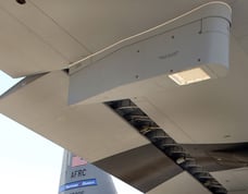
Northrop Grumman Global Hawk Drone: "Severe Storm Sentinels"

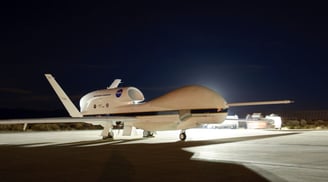
Photo: NASA871 Global Hawk Drone, Edwards Air Force Base, CA Jan. 11, 2012
Turbofan jet engine
Operated by pilots on the ground in USA
Part of Hurricane and Severe Storm Sentinel (HS3) project
Part of SHOUT & multiple other projects
Range: 8,500+ nautical miles (9,782+ miles)
Max flight time: 24-30+ hours (payload/weather dependent)
Ceiling: 60,000+ft (18,288 Meters)
Wing Span: 131 ft (40 Meters)
Planes in service: 1 (NASA872), NASA871 retired
NASA871 (retired) - Over storm payload:
High Altitude MMIC Sounding Radiometer (HAMSR)
High Altitude belly radar (HIWRAP)
Hurricane Imaging Radiometer (HIRAD)
NASA872 - Environmental payload:
Cloud Physics Lidar (CPL)
Scanning High-resolution Interferometer Sounder (S-HIS)
Deploys up to (88) GPS Dropsondes (AVAPS)
Mission: Understand the processes of tropical cyclone formation and storm intensity changes, severe and winter storm research.
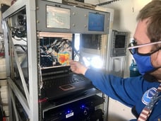
Equipment
Radars, Dropsondes, etc.
Propeller Engines
Why do some Hurricane Hunters use propeller instead of jet engines?
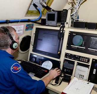
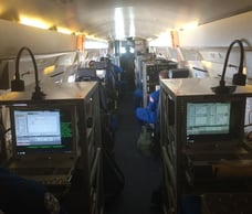
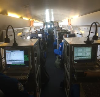
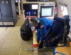
Interior of Planes
You will not find rows of first class seats inside!
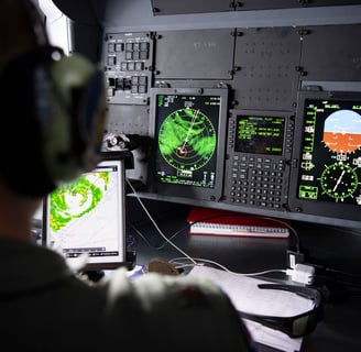
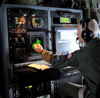
Instead computer stations throughout will greet you.
Radar, communications, and more!
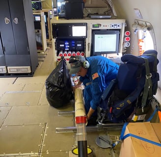
Equipment and gear that may be launched (Dropsondes, AXBT, etc.)
Life-rafts (just in case...)
More efficient for low altitude missions.
Better adapted to lower speed requirements.
Propellers offer greater hail tolerance, if encountered.
Better suited for heavy rain environment.
NOAA Propeller Planes: N42RF, N43RF
USAF Propeller Planes: TEAL70 through TEAL79
NOAA N42RF "Kermit" Tampa, FL Jan. 18, 2017 by Lt. Kevin Doremus (NOAA)


NOAA N43RF "Miss Piggy" Lakeland, FL, 26 Sept 2019, by Jonathan Shannon (NOAA)
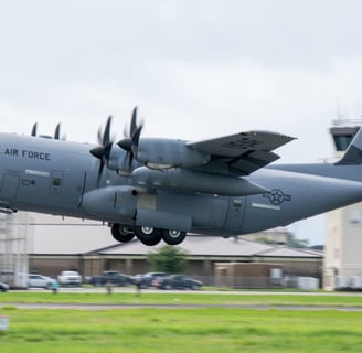
WC-130J Super Hercules taking off to investigate Tropical Storm Elsa Keesler Air Force Base, Biloxi, MS 6 July 2021. U.S. Air Force photo by Staff Sgt. Kristen Pittman


NOAA N43RF "Miss Piggy" flying low level over the ocean in Hurricane Sally 14 Sept 2020, by James Carpenter (NOAA)


NOAA N42RF "Kermit" on Hurricane Awareness Tour 2019, by Kristy Wheless


C-130J Hercules awaiting next Hurricane Florence reconnaissance flight at Savanah Air National Guard base, GA 11 Sept 2018. U.S. Air Force Photo by Technical Sgt. Chris Hibben
NOAA N42RF "Kermit" Tampa, FL Jan. 18, 2017 by Lt. Kevin Doremus (NOAA)
NOAA N42RF "Kermit" and NOAA Gulfstream N49RF "Gonzo" Lakeland, FL 8 June 2021 by Jonathan Shannon (NOAA)
WC-130J tasked with flying into Tropical Storm Chris July 8, 2018 (U.S.Air Force photo/Maj. Marnee A.C. Losurdo)
WC-130J Hercules landing after reconnaissance flight for Hurricane Rita 24 Sept 2005. U.S. Air Force photo by Don Peek
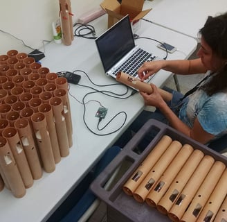
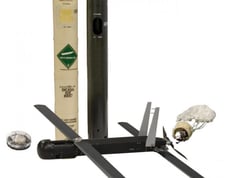
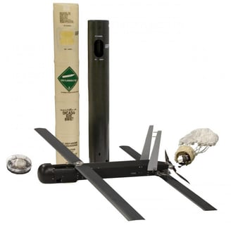
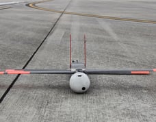
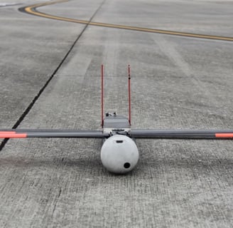
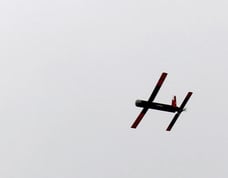
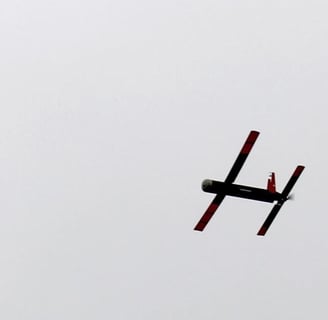
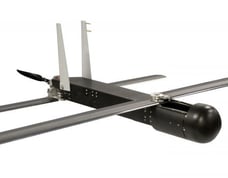
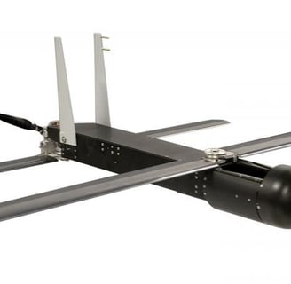
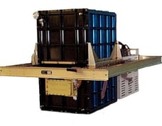
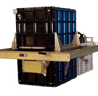
Coyote UAS
Coyote is stored folded up in a tube, launched from aircraft
Once launched tube falls away allowing Coyote to unfold
Unfolded: Wingspan: 1.5m(4.9ft), Length: .9m(2.9ft), wgt. 13LBS.
Focus on low level storm measurements (PBL) in Hurricane eye walls
Increases knowledge of hurricane boundary layer structure, intensity change
Measures: Temperature, moisture, sea surface temperature, pressure and wind speed / direction.
Launched in calm eye to fly into eye wall or launched outside eye wall in storm to eventually reach eye wall (inflow), eventually crashes into sea.
Flight time: 60+minutes, range: 50+miles
Maintainable altitude: Down to less than 120m(400ft)
For more detailed description: https://journals.ametsoc.org/view/journals/bams/101/2/bams-d-19-0169.1.xml


Richard Henning at station aboard N43RF in Hurricane Edouard Sept. 2014 by David Hall (NOAA)
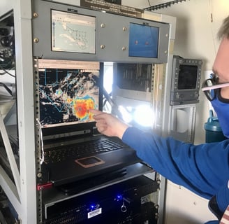
James Carpenter on N49RF pointing to satellite image on laptop TS Laura 22Aug2020 by Cmdr. Jason Mansour (NOAA)
James Warnecke deploying AXBT on N42RF Hurricane Delta 6Oct2020 by Paul Chang (NOAA)
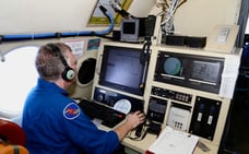
Aerial reconnaissance weather officer Maj. Kimberly Spusta monitors data of Hurricane Laura 25 Aug 2020. U.S. Air Force photo by Senior Airman Kristen Pittman
U.S. Air Force Major Jeffrey Mitchell navigating a WC-130J Hercules for reconnaissance into Hurricane Florence, flying out of Savanah Air National Guard Base, Savanah, GA Airport 13 Sept 2018. U.S. Air Force Photo by Technical Sgt. Chris Hibben)


U.S. Air Force Master Sergeant Tom Barnaby preparing and recording serial numbers of dropsondes before deploying into Hurricane Florence 12 Sept 2018. U.S. Air Force Photo by Technical Sgt. Chris Hibben
Flying out of Hickam Air Force Base, Hawaii, aerial reconnaissance weather officer Lt. Col. Jon Talbot monitors Hurricane Julio off coast of Hawaii 9 Aug 2014. U.S. Air Force photo by Master Sgt. Jessica Kendziorek
U.S. Naval Academy Midshipman First Class Julia Von Fecht aboard a WC-130J Super Hercules readies an AXBT (Airborne Expendable Bathythermograph) for deployment during Hurricane Dorian reconaissance flight 31 Aug 2019. U.S. Air Force photo by Lt. Col. Marnee A.C. Losurdo
Inside NOAA's Gulfstream IV N49RF "Gonzo" as flies around Kiribati Island during 2016 El Nino Rapid Response Field Campaign. Photo by Lt. David Cowan, NOAA.
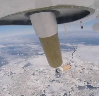
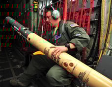
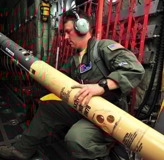
Dropsondes (AVAPS)
Airborne Vertical Atmospheric Profiling System (AVAPS)
16" long, 2.75" diameter cardboard tube with instruments inside
Delivers atmospheric data as falls from aircraft to surface
Parachute deploys upon launch to slow decent
Sends signal back to aircraft in real time
Measures vertical profile of: Temperature, humidity & pressure
GPS enabled for tracking & wind speed/direction
Credited with improving Hurricane forecast up to 20%
Expendable - deployed once
Dozens may be deployed per mission in total
For more detailed description: https://www.eol.ucar.edu/observing_facilities/avaps-dropsonde-system
For model types, accuracy rating etc: https://www.eol.ucar.edu/node/11708

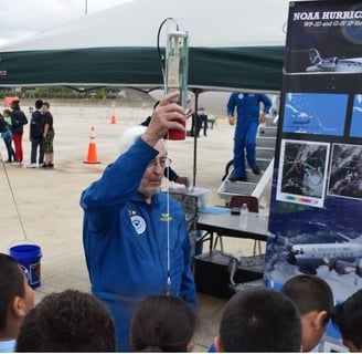

NOAA Aircraft Operations Center Programs Chief Dr. James McFadden demonstrates how a dropsonde works to visitors during the 2017 Hurricane Awareness Tour. Photo by NOAA
Electronics Engineer Charles Lynch (NOAA) releases a dropsonde aboard a WP-3D Orion reconnaissance Hurricane Hunter aircraft over the Gulf of Mexico 25 June 2010. U.S. Air Force photo by Senior Airman Anna-Marie Wyant.
Image underneath a NOAA Twin Otter aircraft showing tube that releases dropsonde with dropsonde just leaving plane. Image courtesy of NOAA/AOC.
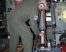
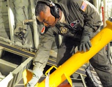
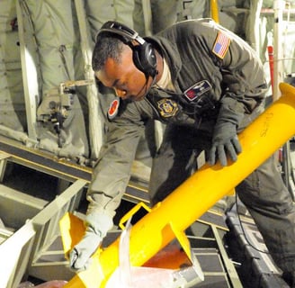
Loadmaster Master Sgt. Erik Marcus places dropsonde into dropsonde cannon about to deploy during Hurricane Harvey reconaissance mission 24 Aug 2017. The dropsonde is released from this tube through a small hole in the aircraft. U.S. Air Force photo/Staff Sgt. Heather Heiney.
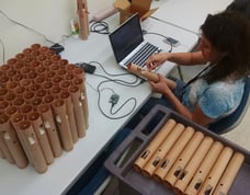
Technician quality checks dropsondes that will eventually be loaded into NASA's Global Hawk under the NASA HS3 Mission. Photo: NASA.


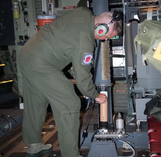
Loadmaster Tech. Sgt. Tom Barnaby reviews a dropsonde in flight into Hurricane Hermine 1 Sept 2016. U.S. Air Force photo/Senior Airman Heather Heiney.
Gary Wick (NOAA ,left), Terry Hock (NCAR, right) holding dropsonde, photo courtesy NASA
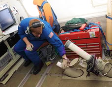
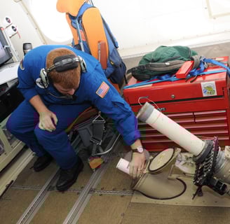
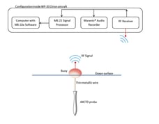
Airborne EXpendable Bathythermograph (AXBT)
Measures the temperature vertical profile in bodies of water
Launched from aircraft in tube about 36" long, about 5" diameter
Parachute lowers to water surface where floats
Floating base station deploys sensor attached by unwinding wire
The sensor measures water temperature every 1.5m (4.9ft)
Signal sent back to base station where antenna transmits data to aircraft
Onboard Weather Radars
Aircraft may have all or just some of these installed.
Nose: Flight safety purpose, under the nose cone. C-Band radar
Lower Fuselage(Belly/LF): Large oval protrusion on lower fuselage. Similar to ground based radar. C-Band radar.
Tail (TDR): Provides near vertical radar & wind image slices. X-Band radar.
For more on NOAA P3 radars see: https://www.aoml.noaa.gov/hrd/about_hrd/HRD-P3_radar.html
Step Frequency Microwave Radiometer (SFMR)
Continuously measures wind data, estimated wind maxima and rain rates directly below aircraft.
Mounted underneath the aircraft.
Detects microwave radiation emitted from sea foam created by storm on ocean surface.
Also known as "smurfs"
Note: See HIRAD further below for newer wide-swath version.
Learn more: https://www.aoml.noaa.gov/hrd/about_hrd/HRD-P3_sfmr.html
Hurricane Imaging Radiometer (HIRAD)
Based on Stepped Frequency Microwave Radiometer (SFMR) and Lightweight Rainfall Radiometer (LRR).
Provides wide-swath detection capability (compared to SFMR's directly below aircraft only capability)
Able to measure up to 80+km (50+miles) swath at a time, can encompass entire Hurricane eye.
Measures wind speed and rainfall rates.
Tested on NASA WB-57 and NASA Global Hawk drone "NASA871"
Expected to transition to satellite based in the future.
Additional info: https://airbornescience.nasa.gov/instrument/HIRAD
Additional info: https://pubmed.ncbi.nlm.nih.gov/28919665/
Additional info: https://stars.library.ucf.edu/cgi/viewcontent.cgi?article=7729&context=etd
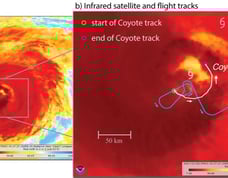
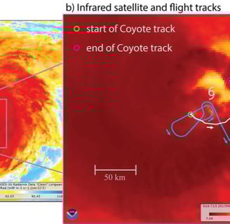
Flight path example of Coyote launched outside the eye and follows inflow track into the Northeast eyewall with position of P-3 airplane shown as well, staying within contact range after launch. Photo: Bulletin of the American Meteorological Society 101, 2; 10.1175/BAMS-D-19-0169.1
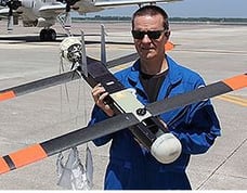
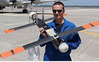
Joe Cione holding Coyote (NOAA/AOML).

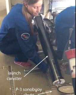
K. Ryan preparing to launch folded Coyote onboard NOAA P-3 plane.
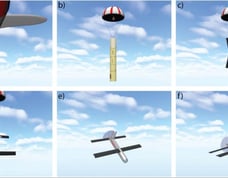
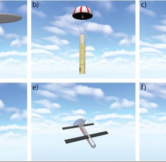
A depiction of the Coyote UAS launch sequence. Courtesy Raytheon Corporation.
Unfolded Coyote, with parachute, and launch tube. Photo by: Raytheon Missiles & Defense.
Coyote unfolded sitting on the tarmac after a successful demonstration flight, 2016. Photo by NOAA.
Coyote in flight. Photo by: Raytheon Missiles & Defense.
Coyote in unfolded flight configuration. Photo by: Raytheon Missiles & Defense.
Loadmaster and dropsonde operator, Master Sgt. Troy Bickham launching an Airborne Expendable Bathythermograph (AXBT) during USAF reconnaissance flight for Hurricane Iselle off of Hawaii 7 Aug 2014. Photo by: U.S. Air Force, Master Sgt. Jessica Kendziorek.
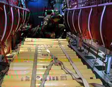
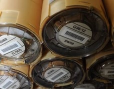

Expendable AXBT's stacked on a WP-3D by Senior Airman Anna-Marie Wyant (USAF).
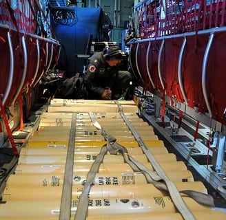
Navy Cmdr. Elizabeth Sanabia (U.S. Naval Academy researcher) securing Airborne Expendable Bathythermographs (AXBT) aboard USAF reconnaissance flight for Hurricane Iselle near Hawaii 6 Aug 2014. Photo by: U.S. Air Force photo/Master Sgt. Jessica Kendziorek.
Side view diagram of Airborne EXpendable Bathythermograph (AXBT) once deployed on ocean surface. Photo: Journal of Atmospheric and Oceanic Technology 32, 2; 10.1175/JTECH-D-14-00114.1.
James Warnecke deploying AXBT on N42RF Hurricane Delta 6Oct2020 by Paul Chang (NOAA).


Weather reconnaissance loadmaster Tech. Sgt. Christopher Becvar (USAF) readies for deployment an Airborne Expendable Bathythermograph (AXBT) out of a WC-130J aircraft in reconnaissance flight for remnants of Dorian 29 July 2013. Photo: U.S. Air Force, Tech. Sgt. Ryan Labadens.
External P-3 NOAA chutes for deploying Airborne Expendable Bathythermographs (AXBT). Photo: NOAA.
EXpendable Bathythermograph probe portion in clear tube, with exploded view of tube on right. Photo from NOAA AOML (Atlantic Oceanographic and Meteorological Laboratory) website.
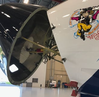
N43RF "Miss Piggy" nose raised revealing radar (small circular white disc). Photo: NOAA.
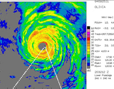
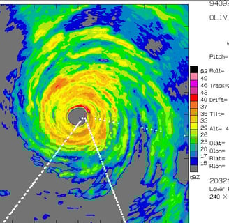
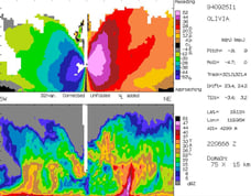
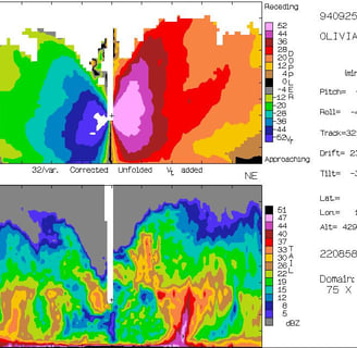
Lower Fuselage (belly) radar image from Hurricane Olivia (1992). Photo: NOAA.
N42RF Lakeland, FL 4 July 2021, dark radar dome just behind front wheel on belly. Photo by Lt. Cmdr. Rannenberg (NOAA).
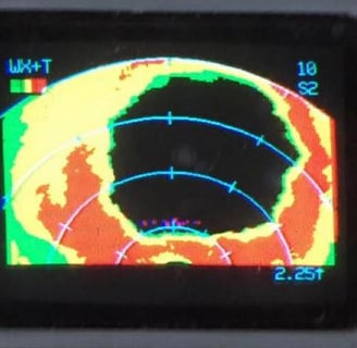
Hurricane Irma vertical tail radar image slice showing eye (devoid of color region) 5 Sept 2017. Photo: NOAA.
"N42RF" tail section with Tail radar housing sticking out back of aircraft. Photo: AOML/ NOAA.
Tail radar image slice from Hurricane Olivia (1992). Photo: NOAA.

Nose radar image of Hurricane Simon (East Pacific) 4 Oct 2014 (NOAA).
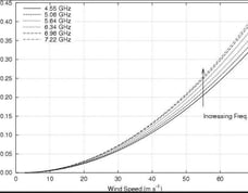
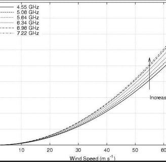
Passive microwave radiation correlation to wind speed chart depending on frequency. Photo: NOAA.
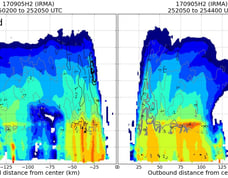
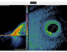
Left: NOAA P-3 tail radar image side view slice of Hurricane Dorian 1 Sept. 2019 where stadium effect shape of strong eyewall is evident. Right: Dorian's eye just able to be seen by KAMX radar (land based Miami, FL radar). Photo was posted on Twitter by @wx_trev 9Sept2019.
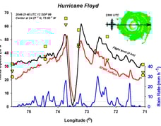
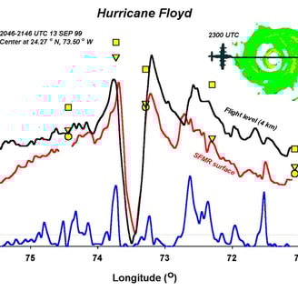
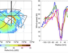
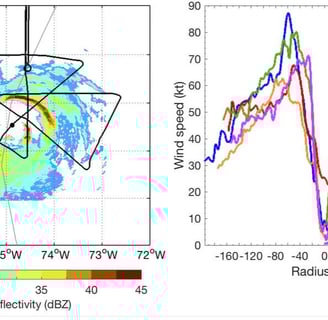
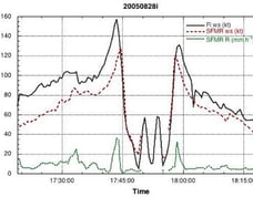
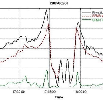
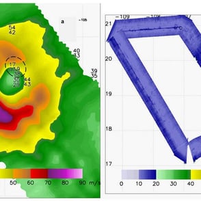
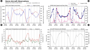
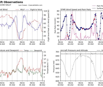
Left: Path of P-3 (Black line) through Hurricane Earl 2 Sept 2010; Right: SFMR wind measurements for each pass through storm, the large dip is the calm eye where little to no wind is found and just outside this dip are the highest winds of the eye wall.=, gradually weaker further away from center of storm. Photo: Monthly Weather Review 147, 1; 10.1175/MWR-D-18-0296.1.
Graph of SFMR readings of Hurricane Katrina 28 Aug 2005 showing black lines (flight level winds), red lines (surface level winds) and green (rain rate). Photo from: NOAA.
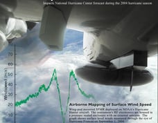
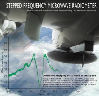
SFMR mounted on underside of wing on NOAA P-3 Hurricane Hunter aircraft, just below the word "Frequency" on image. Also shown in image is belly radar in the black Skittle shaped protrusion on the right side of image underneath the plane. Green chart on image is sample wind speed chart detected while passing through Hurricane Francis 1 Sept 2004. Photo: NOAA.
Sample data graph created from SFMR data from Hurricane Floyd 13 Sept 1999 showing flight level winds, surface level winds and rain rates. The large dive down in the middle is the eye which is typically calm with no winds inside, with highest winds on each side of it representing the ferocious eye wall. Photo: NOAA.

SFMR mounted underside of wing on aircraft. Photo by Maj. Chad Gibson (USAF).
High Altitude Winds and Rain Airborne Profiler (HIWRAP)
Dual frequency, dual band conical radar system
more coming soon.
Precipitation and Cloud Particle Probes
more coming soon.
Air-Launched Autonomous Micro Observer (ALAMO)
more coming SOON.
Additional info: https://www.aoml.noaa.gov/news/alamo-floats-cleared-for-deployment/?utm_source=socials+&utm_medium=twitter&utm_campaign=Alamotweet
High-Altitude MMIC Sounding Radiometer (HAMSR)
Measures temperature, water vapor, and liquid water in the atmosphere.
More information coming soon.
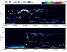
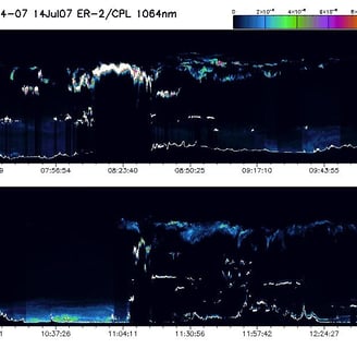
Cloud Physics Lidar (CPL)
Lidar system, operates three nm wavelengths
Multi-wavelength measurements of cirrus & aerosols
Learn more: https://airbornescience.nasa.gov/instrument/CPL
Additional info here: https://ghrc.nsstc.nasa.gov/home/micro-articles/instrument-cloud-physics-lidar-cpl
Scanning High-resolution Interferometer Sounder (S-HIS)
Interferometer(purposely merge light sources to create interference pattern)
This particular interference pattern measures thermal radiation
That measurement resolution: 3.3 - 18 microns
In turn this gives temperature and water vapor in Earth's atmosphere
Sounding data produced resolution: 2km over 40km ground swath
Read more: https://airbornescience.nasa.gov/instrument/S-HIS


Sea surface as seen from low altitude flight of USAF Hurricane Hunter recon aircraft during Hurricane Florence 12 Sept 2018. Photo by: Technical Sgt. Chris Hibben (USAF).
Photo descriptions:
HIRAD system installed underneath NASA871 Global Hawk drone 27 Sept 2012. Photo: Dave Fratello.
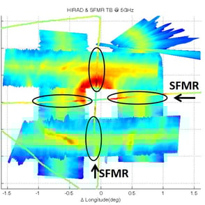
HIRAD imagery over Hurricane Patricia 23 Oct 2015 in the East Pacific just off the coast of Mexico. Left: closeup of eye area, numbers are dropsonde wind measurements. Image courtesy Josh Cossuth and the NRL Monterey Tropical Cyclone web page team, from Journal of Atmospheric and Oceanic Technology 34, 8; 10.1175/JTECH-D-17-0031.1 - https://journals.ametsoc.org/view/journals/atot/34/8/jtech-d-17-0031.1.xml
Concept computer graphic simulation of the path HIRAD traces over a hurricane from a NASA Global Hawk drone high above the storm. Photo: NASA.
HIRAD wide swath detection versus smaller SFMR passes. The comparison shows the large advantage HIRAD offers over the previous SFMR system. Image: from 66th Interdepartmental Hurricane Conference, Charleston 2012 presentation slide by Office of the Federal Coordinator for Meteorology.
Related equipment. Photo from NASA website.
Related results. Photo from NASA website.
Equipment used varies based on a variety of factors including mission and scientific goals, plane type, as well as changes in technology.
Stock Aircraft Imagery/Videos
Most are free to use - see sites for credit to be given / policy
NOAA Hurricane Hunter Images:
Note: Change "Topic" to "Hurricane Hunters", then "Apply". NOAA photos of Hurricane Hunter aircraft, personnel, other equipment and storms. Click item for photo details, credit and copyright.
NOAA Hurricane Hunter Videos:
Note: Change "Topic" to "Hurricane Hunters", then "Apply". NOAA videos of Hurricane Hunter aircraft, personnel, other equipment and storms. Click item for video details, credit and copyright.
USAF Hurricane Hunter Imagery / Videos:
Click item for image details, credit and copyright.
Global Hawk Drone Imagery:
Click item for image details, credit and copyright.
Global Hawk Drone Video:
Click item for image details, credit and copyright.
History
Reconnaissance Flights Near Storms:
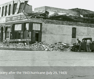
First Flight into the Eye:
It all started on a bet...
While reconnaissance flights near hurricanes to track them had been employed for many years, it wasn't until 27July1943 that the first known flight through the eye of a hurricane was made. Lt. Col. Duckworth was at a bar when a bet was made (as the story goes anyhow!) with visiting British pilots that it couldn't be done. The first flight was made by Duckworth along with navigator Lt. Ralph O’Hair taking off from Bryan Field and flying near Galveston, TX where 1943's Cat2 'Surprise Hurricane' was making landfall. After their return to base meteorologist Lt. William Jones-Burdick rode up with Duckworth into the storm.
Ships have been no stranger to tropical cyclones for centuries. Weather and sea conditions recorded by their crew over time have created an immense historical data collection of tropical system activity and knowledge base and help provide advance warning to those on land. Early aircraft continued this endeavor, flying out around storms, relaying storm positions and provide additional observations back to weather forecasters. With Hurricanes typically moving at about the same speed as someone on a bicycle, aircraft can spend a decent amount of time observing and tracking a storms before returning to base. The practice of flying aircraft around the outer edges of a Hurricane is still used today, helping feed valuable information back to forecasters and computer models (ie: NOAA Gulfstream IV "Gonzo"). For flights into the heart of the storm, see further below.


Lt. Col. Duckworth 1942
(Columbus & Starkville Dispatch)

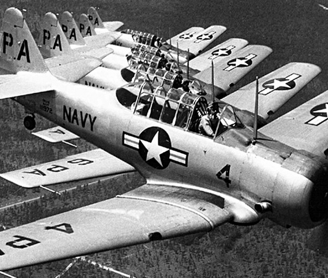
Single Engine AT-6 “Texan” trainers
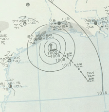

Hand drawn surface analysis
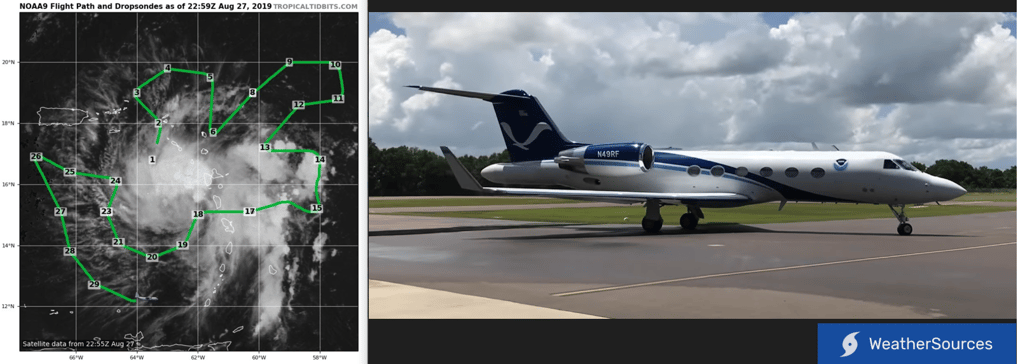
NOAA49 "Gonzo" path around tropical system 27Aug2019 (left, via TropicalTidbits website), photo of "Gonzo" (right, via NOAA)
Today NOAA and USAF 'Hurricane Hunter' aircraft still fly through the eye of a hurricane. This generates valuable in storm observations which have marked improvements on hurricane forecasting: "The information collected makes possible advance warning of hurricanes and increases the accuracy of hurricane predictions and warnings by as much as 20 percent" -USAF 403rd Wing.

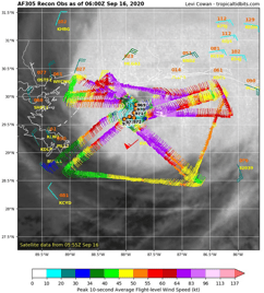
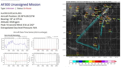
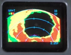
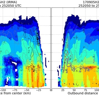
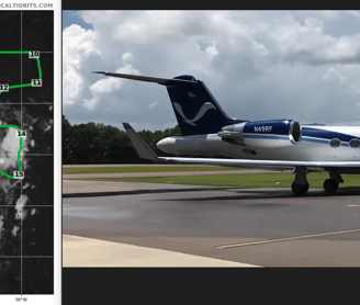
Data from inside Hurricane by plane
(Data visualization by TropicalTidbits)
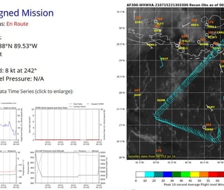
Data from inside Hurricane by plane
(Data visualization by TropicalTidbits)
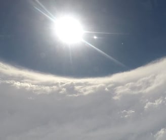
Clear eye of hurricane as seen by in storm Hurricane Hunter
Other Weather Recon Aircraft
So much atmosphere, so little planes
Interactive map of some NOAA aircraft. Full interactive map and plane details can be accessed here: https://airbornescience.nasa.gov/tracker/ (Page loads to plane details, clock MAP at top of page for interactive map).
NOAA / NASA Aircraft