
Hurricane FAQ
Frequently Asked Questions
Classification
Just because it spins - doesn't mean it's Tropical


Cyclone, Hurricane, Typhoon. What's the difference?
Cyclones, Hurricanes and Typhoons are all the same and are considered to be 'Tropical Cyclones'. The terms mainly depend on where in the world they form but are sometimes used interchangeably:
Cyclone: South Pacific, Indian Ocean, South Atlantic, Mediterranean
Hurricane: Central and East North Pacific, North Atlantic
Typhoon: West North Pacific
These names have their origins in regional languages and overall are related to describing a great wind storm. The term ‘Cyclone’ is used to describe a Low Pressure system, but here in this context it is referring to a Tropical Cyclone.
What is a Tropical Cyclone?
While still a Low Pressure weather system (and therefore also referred to as a ‘Cyclone’), Tropical Cyclones (Hurricane, Cyclone, Typhoon) differ from other storm systems by drawing their energy from warm water heat energy, have a warm core, not part of a frontal system, originate over tropical or subtropical waters, have organized deep convection and a closed low level circulation. For a further breakdown of these factors see ‘Hurricane Formation Factors’ FAQ.
What is a Tropical Wave?
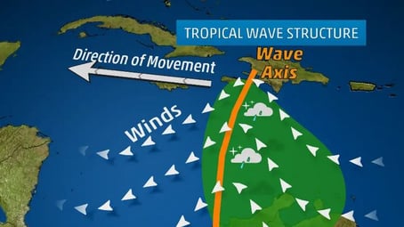
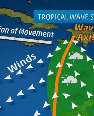
Elongated areas of Low Pressure, or a Trough, generally oriented in a North - South direction that move along within the trade winds. For the North Atlantic these mostly move in an East to West direction, typically seen between Northern Africa and into the Caribbean. Sometimes satellites can show a general upside down ‘V’ shape along this wave axis. In general there may be scattered showers and breezy conditions within but sometimes these eventually develop into and can be one source of a Tropical Cyclone. In the Atlantic around 60 or so are seen each year with the majority occurring in the June to August time period. These may be designated as ‘Invest’ if they begin to show, or modeling shows, more Tropical Cyclone development potential.
Example of the typical structure of a tropical wave moving through the Caribbean. (Image credit: The Weather Channel)
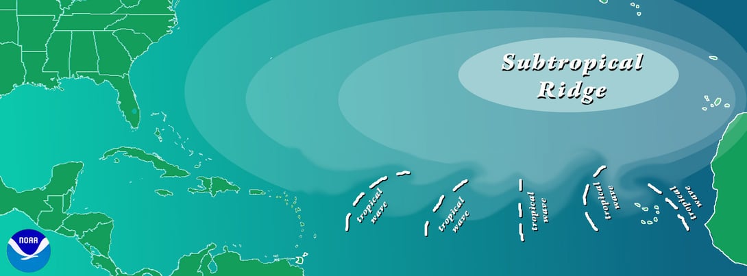
Sample map of what a tropical wave may be oriented or how it moves. (Image credit: NOAA)
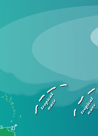
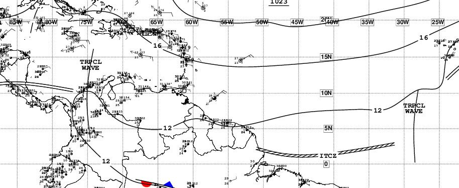
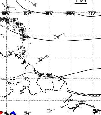
NHC TAFB surface analysis map showing two tropical waves 17 May 2022. (Image credit: NHC/NOAA)
What is an Invest?
An Invest is an area of disorganized scattered showers and breezy conditions that has Tropical Cyclone development potential that has been officially designated as an area of interest, or investigative area.
An Invest may be a Tropical Wave, a Low Pressure system, or any area with Tropical Cyclone development or transition potential. Designation as an Invest allows academic and government agencies to task data collection & analysis activities of the area of interest. An Invest typically precedes the declaration of a Tropical Depression or named Tropical Storm which are stronger and more organized weather systems. Not every Invest develops into a Tropical Cyclone and not every Cyclone starts off classified as an Invest.
Invest are labeled around the globe by "##X" (Number Number Letter) format in order to monitor and communicate information about possible future development. The numbers and letters are specific to each basin (see list below). Each basin starts the season with number 90, increasing by 1 each area of interest in that basin until reaching 99, then repeats starting from 90 again (ie: 90, 91...98, 99, 90, 91, etc.). Be sure to check dates when viewing specific Invest information due to the repeating numbering system as Invest may only last a few days. Numbers in the 80's are typically reserved for testing. Following the number is a letter which represents which basin the area of interest is located in. Examples of Invest numbering: Invest 92L, Invest 90E, 98S etc.
Basin Letters:
A = Arabian Sea
B = Bay of Bengal
C = Central North Pacific
E = East North Pacific
L = North Atlantic (including Gulf of Mexico & Caribbean)
M = Mediterranean
P = South Pacific (including Australian region East of 135deg)
Q = South Atlantic
S = South Indian Ocean (including Australian region West of 135deg)
W = West North Pacific
In the North Atlantic, Central and East North Pacific an Invest may be declared a Potential Tropical Cyclone (PTC) if development is highly likely (See ‘What is a PTC (Potential Tropical Cyclone)?’ further below for additional details). When the US National Hurricane Center (NHC) is issuing regular or special Tropical Weather Outlooks (TWO), the formation chances of these invest are given, typically divided into three separate groups of 0-40%, 40-60% and 60+% chance (reference ‘What are the Two Day and Five Day Graphical Tropical Weather Outlooks(TWO)?’ for further information).
What is a PTC (Potential Tropical Cyclone)?
Potential Tropical Cyclones (PTC) were implemented by the US National Hurricane Center (NHC) starting in 2017. The purpose of a PTC is to give advanced lead time on communicating potential tropical cyclone hazards and other details prior to a storm actually developing or organizing enough to be classified as a tropical cyclone. PTC designation can be used for this purpose if Tropical Storm or Hurricane force winds are possible on land within 48 hours or less. This grants the NHC the ability to issue the full suite of tropical cyclone advisory products including five day cone map, wind probabilities, text advisories, storm surge information, Tropical Storm and Hurricane Watches and Warnings, etc. Prior to PTC’s the NHC did not publish these advisory products because of storm classification.
PTC’s are numbered the same way as Tropical Depressions or any other designated tropical cyclone for each calendar year by taking the next available number for that basin. If ‘Tropical Depression Two’ was the last storm advisories were issued on then the next system would be ‘Three’ whether it was declared a PTC, Tropical Depression or Storm. The next would be ‘Four’ and so on. Just like other tropical cyclone advisory products, the NHC updates PTC system information every six hours at 5 & 11am/pm EDT. When Tropical Storm or Hurricane Watch and Warnings are posted updates are added at 2 and 8am/pm EDT. PTC products are only issued by the NHC for the Central and Eastern North Pacific and North Atlantic basins.
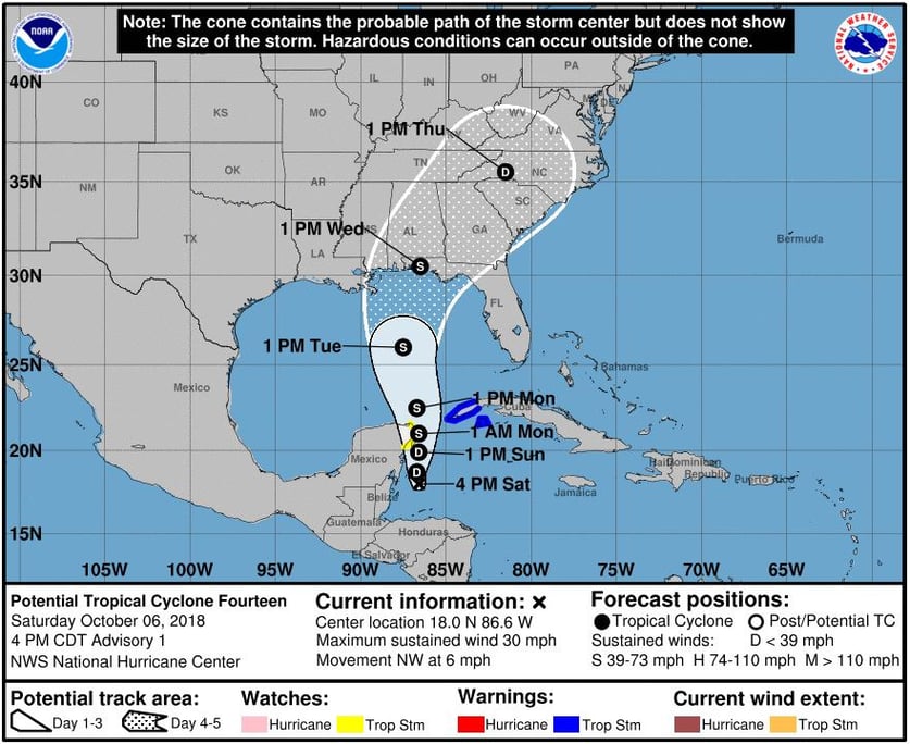
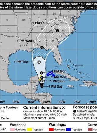
PTC five day cone of uncertainty map for what would later become Cat5 Hurricane Michael 6 October 2018 before it formed. (Image credit: NHC/NOAA)
What is a Tropical Depression?
A Tropical Depression (TD) is a Tropical Cyclone (TC) with sustained winds of 38mph (61km/h, 33knots) or less, but can have higher wind gusts.
A Tropical Depression may cause a wide range of impacts or barely be noticed at all (Each storm is different). Tropical Depressions typically do not prompt evacuations and there are no ‘Tropical Depression Watch’ or ‘Warning’. These storms can still be deadly and cause damage including spawning tornadoes, inland flooding from excessive rainfall, scattered downed trees, scattered power outages, storm surge flooding, etc. It doesn't take a named Tropical Storm to cause major impacts.
While not named, a Tropical Depression is numbered starting at 'One' each calendar year, increasing in increments of one with each successive storm. The numbers are specific to each basin. Similar to Invest, some basins place a letter after the number to identify which basin such as the East North Pacific (E) and South Indian Ocean (S). While the Atlantic invest letter is ‘L’, it is typically left off (ie: ‘OneE’ (East North Pacific), ‘One’ (North Atlantic), ‘TwoW’ (West North Pacific), etc.). See ‘What is an Invest?’ above for a full basin letter list). If a storm becomes a named Tropical Storm the name takes precedence, but the storm still retains its original number and basin letter (ie: ‘01L’, ‘02E’, ‘02L’ etc.). If a storm more rapidly develops and is declared a named Tropical Storm instead of Depression it still has the next number that would have been given. Storms in the Northern Hemisphere spin counterclockwise while those South of the equator spin clockwise.
Note: WeatherSources uses the Saffir-Simpson scale 1-minute sustained wind speed average at 10m (33ft) for storm classification while other areas of the world outside of the North Atlantic or Central and East North Pacific may use other scales and/or timed wind speed averages for wind/storm classification.
What is a Tropical Storm?
Tropical Storms (TS) are Tropical Cyclones (TC) with sustained winds that can range from 39mph to 73mph (63-117km/h; 34-63knots) with higher wind gust speeds.
With a wide range in wind speed Tropical Storm impacts can vary from similar to a Tropical Depression to more like a Cat1 Hurricane. All Tropical Storms can be deadly and all can cause a wide range of impacts including spawning tornadoes, wind damage to property, inland flooding from excessive rainfall, scattered downed trees, scattered power outages, storm surge flooding, etc. See ‘Hurricane Impacts’ FAQ for further details of these impacts.
Tropical Storms are given a unique name for that season/year from a name list that is specific to each basin. See ‘Hurricane Names’ FAQ for more information on naming.
In the Atlantic, these storms can form any month, but are more typically seen in the late May to December time period, majority in August through October with peak activity around mid September on average. Storms in the Northern Hemisphere spin counterclockwise while those South of the equator spin clockwise.
Note: WeatherSources uses the Saffir-Simpson scale 1-minute sustained wind speed average at 10m (33ft) for storm classification while other areas of the world outside of the North Atlantic or Central and East North Pacific may use other scales and/or timed wind speed averages for wind/storm classification.
What is a Hurricane?
Hurricanes are Tropical Cyclones (TC) with sustained winds of 74mph or greater (119km/h+, 64knots+) and even higher wind gust speeds.
Hurricanes can cause a wide range of impacts including spawning tornadoes, wind damage to property, inland flooding from excessive rainfall, widespread downed trees, widespread power outages, storm surge flooding, etc. See our ‘Hurricane Impacts’ FAQ for further details of these impacts.
The anatomy of Hurricane generally consists of a central eye feature of calm winds and sometimes sunshine immediately surrounded by a ring of the strongest winds known as the eyewall. Outside of this rain bands are typically seen, each with heavy rains and winds decreasing in speed the further away from storm center they are. For more details and storm features please see our ‘Hurricane Anatomy’ FAQ.
Hurricanes retain their name given when they became a Tropical Storm and are assigned one of five categories based on their sustained surface wind speed. In the North Atlantic, East and Central North Pacific these categories are based on the Saffir-Simpson scale from Category 1 (least powerful) to Category 5 (most powerful).
Although Hurricanes can form any month, in the Atlantic they are mainly seen in the late May to December time period with majority in August through October and peak activity around mid September on average. Storms in the Northern Hemisphere spin counterclockwise while those South of the equator spin clockwise.
Note: WeatherSources uses the Saffir-Simpson scale 1-minute sustained wind speed average at 10m (33ft) for storm classification while other areas of the world outside of the North Atlantic or Central and East North Pacific may use other scales and/or timed wind speed averages for wind/storm classification.
What is a Major Hurricane?
The term Major Hurricane refers to any Hurricane in the North Atlantic, East and Central North Pacific that is rated on the Saffir-Simpson scale as Category 3, 4 or 5 (the strongest three levels of that scale). These Hurricanes can cause considerable widespread & potentially extreme damage.
The majority of Major Hurricanes in the North Atlantic basin occur in the August to October time period but can sometimes be found outside that. On average, most Major Hurricanes originate in the MDR (Main Development Region) in an area between Northwest Africa and the Caribbean.
What is a Category or the Saffir-Simpson scale?
Hurricanes in the North Atlantic, Central and East North Pacific are rated as a Category number from least powerful to most powerful of ‘One’, ‘Two’, ‘Three’, ‘Four’ or ‘Five’ based on the Saffir-Simpson Hurricane Wind Scale. This scale rates a Hurricane based on the 1-minute sustained wind speed average at 10m (33ft) with Category Five being the most powerful.
The highest winds in a hurricane are typically found in the eye wall around the storm's central eye feature, generally lessening the further away from this feature you are. Winds increase in speed the higher up you are, so mountainous areas or skyscrapers can actually see higher winds than a storm is rated at. Wind speed can be measured in a variety of ways including but not limited to satellite interpretation, in storm measurements by aircraft, dropsondes, drones, land and ship based instrumentation, etc.
The Saffir-Simpson scale is as follows:
Category 1: Winds 74-95mph (119-153km/h; 64-82knots)
Category 2: Winds 96-110mph (154-177km/h; 83-95knots)
Category 3: Winds 111-129mph (178-208km/h; 96-112knots)
Category 4: Winds 130-156mph (209-251km/h; 113-136knots)
Category 5: Winds 157mph+ (252km/h+; 137knots+)
Additional information can be found from the US National Hurricane Center (NHC) here: https://www.nhc.noaa.gov/aboutsshws.php
Is there a Cat6?? Officially no. You may see some online social media post or news headlines that tout a Cat6, it's usually attention seeking / clicks. Being different stands out. And in emergency situations sudden changes grab peoples attention and some algorithms then help promote those post even more accordingly based on user interactions.
Should there be a Cat6? Some would argue yes with advancements in science, satellite and other sensing technologies and in storm data feeds more reliable data points and observations can be gathered. Damage from winds, similar to earthquakes, is exponential in nature. Not all Cat 5's are equal. Some meet the wind threshold and obtain Cat5 status, while others appear to be 'perfect' in appearance (Prime examples include Hurricane Patricia (2015), Super Typhoon Hayien (Yolanda) (2013) and Super Typhoon Goni (2020)). Some argue against another storm category as once winds reach Cat5 does it really matter anymore? Advancements in building codes may mean a Cat6 possibly added at some point in the future though.
What is a SubTropical storm?
SubTropical storms are a transitional or hybrid system that can slowly become a full fledged Tropical Cyclone. They are named and treated like the next Tropical Storm with sustained winds that range between 39mph to 73mph (63-117km/h; 34-63knots) or Depression with winds less than 38mph (61km/h, 33knots) with higher wind gust speeds but don't meet the full definition of a Tropical Cyclone.
These systems generally differ in structure to traditional Tropical Cyclones in that the strongest winds are well removed from the center (typically 100miles(161km) or more away), have a more comma like or asymmetric appearance, are not warm core (warm core systems have storms near their center which moistens and warms the lower levels feeding the storm by the latent heat released as water vapor from warm waters condenses back into liquid water), and a large cloud free center of circulation.
SubTropical Storms in the Atlantic have been named since 2002 (prior to this they were only numbered) if winds are 39mph (63km/h; 34knots) or higher and use the next available name from the regular Tropical Cyclone name list for that year and basin. While there can also be SubTropical Depressions, there are no SubTropical Hurricanes.
What is a Post Tropical Cyclone?
Tropical Cyclones that lose their tropical characteristics are referred to as Post Tropical Cyclones. These systems no longer meet the definition of a Tropical Cyclone and are generally classified as a Remnant Low or an Extratropical Cyclone. Post Tropical Cyclones can still be powerful Hurricane like systems (such as ‘Post-Tropical Cyclone Sandy’ in 2012) or just a swirl of harmless spinning clouds void of any storms, or anywhere in between.
In general, Tropical Cyclone advisories, Hurricane and Tropical Storm Watch and Warning are discontinued after a system reaches Post-Tropical Cyclone status. Lessons learned after Hurricane Sandy (2012) brought about changes to this policy for the US National Hurricane Center (NHC) in that if a system is still affecting land or near land then Tropical Cyclone advisories will generally continue as needed. This helps keep a more consistent message for public safety and preparedness.
What is an Extratropical Cyclone?
An Extratropical Cyclone is a type of Post-Tropical Cyclone, a system that has lost it’s Tropical Cyclone characteristics (but still may be a powerful Hurricane like system). These systems generally have a poleward motion and derive its energy from baroclinic processes (temperature difference between warm and cool air).
What is a Remnant Low?
Remnant Low’s are a type of Post-Tropical Cyclone, generally referring to a system that has lost deep convection and no longer meets the definition of a Tropical Cyclone. This is more commonly seen when a Tropical Cyclone has undergone high wind shear, blowing storm tops away leaving just a swirl of harmless spinning clouds with winds less than 39mph (63km/h; 34knots).